
Biloxi's Shoreline Through the Years
Posted by Paige Gutierrez on Sep 28th 2023
This article originally written by Paige Gutierrez with the title "Along the Shoreline". Paige is a local Biloxi writer for BNews Monthly, the monthly newsletter of the City of Biloxi. Photographs courtesy of the LHG Image Collection / Local History & Genealogy Department / Harrison County Library System unless otherwise specified.
The shoreline of the Mississippi Sound in Harrison County has been transformed over the years from its natural state into twenty-six miles of sand beach, seawall, highway, and drainage infrastructure. What was it like near the water’s edge before today’s man-made shoreline? Here are some photos of the shoreline before the highway, before the seawall, and before the dredged-in sand beach.
Biloxi’s early twentieth-century shoreline road was called the Shell Road. It was paved with crushed shells from the then-booming oyster canneries. The Shell Road was re-named Old Spanish Trail in 1918. In 1925, Old Spanish Trail became U.S. Highway 90. Source: The Old Spanish Trail: The Story of a Modern American Highway by Charles L. Sullivan. Photo above from Library of Congress.
 In 1901, there were twenty-five small wooden bridges on the shoreline road that would later become Highway 90. Each bridge indicated the presence of freshwater entering the Mississippi Sound from bayous, spring-fed streams, swamps, and marshy lowlands. The estuaries thus created helped support the abundant sea life that gave the coast a national reputation as a fisherman’s paradise. Source: The Old Spanish Trail: The Story of a Modern American Highway by Charles L. Sullivan; Human-Environment Relationships along the Mississippi Coast by Klaus J. Meyer-Arendt. Photo: MDAH.
 In the early 20th century, a trolley brought visitors to a wooded area in west Biloxi near the shore known as Presque Isle, French for “almost an island.” This large spit of land south of the roadway extended from Rodenberg Avenue westward to the area of today’s Treasure Bay Casino. At Presque Isle, people picnicked among the oak, pine, and cypress trees, hunted, fished in a lagoon, and built campfires on the shore to cook their catch on the spot. Floundering and soft-shelling were popular on warm evenings. Presque Isle was destroyed with the building of the seawall in the mid-1920s. By mid-century, most remaining trees were cut for building popular night clubs and family tourist attractions. Today, what was once Presque Isle includes Restaurant Row and the West Biloxi Boardwalk. Source: “Presque Isle all but forgotten” by Murella Powell, The Sun Herald. Photo from Biloxi Library Local History and Genealogy Collection.
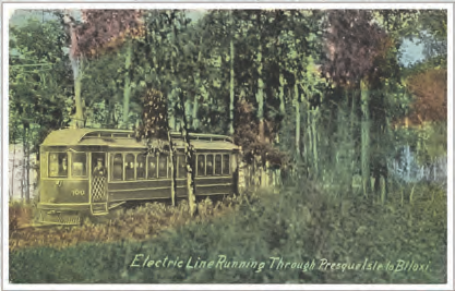
 This postcard shows a trolley traveling “from Gulfport to Biloxi,” near the water’s edge. The Gulfport and Mississippi Coast Traction Company was founded under the leadership of Gulfport’s Joseph P. Jones in the early 1900s. The company operated a small power generating plant and an electric rail line that traveled the shore from Pass Christian to Biloxi. The route was scenic, but its proximity to the shoreline meant sand on the tracks, erosion, and storm damage. Service ended with the building of the seawall. Mississippi Power Company was established in 1925, when it took over the assets of the Traction company. Source: The Daily Herald; Mississippi Power; Historical Society of Gulfport. Photo: Historical Society of Gulfport, Paul Jermyn Collection.
 The roadprotecting seawall was designed by Dutch engineers and built between 1924 and 1928. Originally there was a small natural beach fronting the steps of the seawall, but wave action gradually eroded it away. After the destructive 1947 hurricane, the U.S. Army Corps of Engineers recommended the creation of an artificial sand beach to protect the seawall and highway; that project was carried out in 1951-52. Source: The Daily Herald. Photo: MDAH Randazzo Collection.
 Rocks help protect the Biloxi lighthouse from erosion in 1901. The people on the small beach are standing on what is now the east-bound side of Highway 90. Photo from Library of Congress.
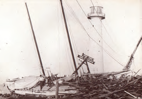
The 1915 hurricane damaged the shoreline Shell Road and prompted the building of the seawall. Photo from Joe Scholtes Collection.
###
Hungry for shrimp? Visit our Shop page to order wild-caught Gulf shrimp to be shipped to anywhere in the country today!